EarthView team bios, guidelines, and more.

Tuesday, November 29, 2011

Wonders of Nature


The Seven Wonders of the Ancient World are ancient marvels of human ingenuity that were chosen by a handful of individual Greek and Roman writers over a period of several centuries. Several lists were drawn up, all of which included constructed sites in the general vicinity of the Mediterranean Sea (whose name, after all, means, "In the Middle of the Earth").

In 2011, a project endeavored to identify a new Seven Wonders list, this time of natural features and this time chosen more democratically. Steve Curwood of Living on Earth recently interviewed the Eamonn Fitzgerald, who helped lead the effort. The 28 finalists are shown on the map below and described on the finalists page.


The list of Seven Wonders was announced on November 11 and is awaiting final certification. Geography students of all ages can, however, use the original list of finalists to organize their own votes and other educational activities.

For example, using latitude and longitude or a globe, students can identify the finalist locations closest and farthest from home, closest to each other, remotest from each other, farthest north or south, and so on. Finalists can be categorized as biological or geological wonders, or in a variety of other ways. What are the local languages (official and perhaps indigenous) spoken in the vicinity of each? Which are most threatened by human activities and why?

Language and Lands Beyond

The National Public Radio (NPR) program All Things Considered is a daily radio show that includes a lot of different perspectives on news, science, and the arts. Although meant primarily for adults, many middle school and high school students learn a lot -- including a lot of geography -- from the program. It has been archived online for several years, so searching the archives is a good way to find a radio story about almost any area of the world.

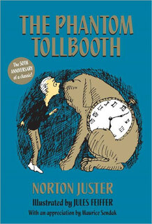
On November 29, the program included a lovely story about the 50th anniversary of a children's book that almost did not get published. As many adults now understand, most children love language and wordplay. When author Norton Juster and illustrator Jules Feiffer first offered The Phantom Tollbooth, however, publishers thought it was too sophisticated for children!

The book is known mainly for its fun with language and for the interactions between words and images. In the interview between Michelle Norris and Norton Juster, though, it is clear that this is also a great book for young geographers! Once Milo starts exploring the lands beyond the tollbooth, he cannot help but continue to explore more and more.

Members of the EarthView Team are like young Milo in the story. Among us, we have been to all the towns in Massachusetts, all the counties in New England (one of us has done that individually!), all fifty of the United States, and more than 60 countries around the world. To do this travel, we have learned languages, consulted maps, and sometimes just taken a chance to travel for no reason other than to see what was over the next horizon!

Monday, November 28, 2011

Spofford Pond School, Boxford -- Dec 2

42°41'46"N 
71°01'02"W
(Visit more about Lat/Long for ideas that combine math and geography learning. This is our second visit to Spofford Pond, and it remains the farthest north we have taken EarthView.) 

The town of Boxford is currently involved in an interesting project that will eventually benefit the entire region. According to a recent article in The Tri-Town Transcript (a great name for a local paper!), many people from Boxford turned out for a recent meeting to learn about the section of the Border to Boston Trail that is planned for the eastern portion of the town.

Because team member Dr. Hayes-Bohanan has a lot of friends and former students in South America, the first he heard of the current volcanic activity in Ecuador was in Portuguese! (What country was this former student writing from?)

According to BBC News, the Tungurahua volcano is currently emitting a plume of ash nearly to the top of the troposphere, and schools have been evacuated. So far the activity has not caused any damage, but over the past dozen years, this volcano in the middle of the Andes has been quite active, so authorities are being very cautious. 

Tungurahua is not a Spanish name, by the way. It is of Quichua origin and may simply mean "crater" though the more interesting possibility is that it means "Throat of Fire." The volcano is in a province of the same name, and is located at  1°28′01″S; 78°26′30″W. How does that compare to the location of Spofford Pond School? What is the nearest point in North America with the same longitude as the volcano?

We encourage our Spofford Pond students to use the "Comments" link below to send us their questions or comments about geography.

Our visit takes place on December 2, the anniversary of several events with geographic significance:

1802 The British sold Suriname to the Dutch. (Because he speaks both of these languages, Dr. Domingo was successful as a Fulbright Scholar in Suriname, and is now considered a leading expert on the country.)

1823 President James Monroe Declared the Monroe Doctrine, discouraging European countries from involvement in the Western Hemisphere

1899 The United States and Germany agree to divide Samoa between them; Samoa eventually became independent, but American Samoa is still a U.S. Territory. Look for both of them on EarthView.

1933 Bertil Clason (of Detroit, Michigan) and Sigrid Carlson (of Stockholm, Sweden) married in the first transatlantic wedding officiated by telephone.

And as Spofford School students know -- December 2 is Crazy Hair Day!

Monday, November 14, 2011

Better not Bottled


Most Americans used to get water from the tap. A five-minute cartoon narrated by Annie Leonard, The Story of Bottled Water explains how this changed in one generation. Many Americans now willingly pay $6 to $8 per gallon for their drinking water, generating a half-billion bottles of wasted plastic every week!

As with all of her "Story of Stuff" videos, Leonard does not just complain about a problem. She explains it as part of helping people think about how to solve the problem. This is five minutes of video every person should see!

Saturday, November 12, 2011

Gates Intermediate School, Scituate -- November 18

42° 11' 59" N
70° 45' 18" W
Learn more about Lat/Long

The EarthView team will be making its first visit to Scituate. The name of the town is derived from a Wampanoag word for the "cold brook" that feeds its harbor, but coincidentally sounds like an English word for an important geographic concept!

Because geography is the study of places, geographers are very interested in the many ways in which places can be described, categorized, and compared. Geography distinguishes between two equally important ways of describing places: site and situation. In choosing where to locate a new settlement (or a store or a house or an office), characteristics of the place itself (site) must be balanced with its position relative to other places (situation). The web site of the Barcelona Field Studies Centre lists several examples of site and situation relative to the location of that city. 


What are the site and situation (or scituation) characteristics that led to the settlement of Scituate? What aspects of each continue to make it a popular place to live?


Geography Happenings on November 18 


1993 A record for November cold was set on this date, when the temperature in North Siberia reached negative 55 degrees Celcius (that's negative 67 Farenheit)! Siberia is known for temperature extremes because of its position in the upper-mid latitudes and its continentality. A look from inside EarthView confirms that the interior of Asia is farther from the moderating influence of oceans than is any other place on earth. Incidentally, the radio program On Point recently featured an interview with Ian Frazier about his travels in Siberia, in which he discusses the human and physical geography of this place that is both vast and remote. 
Vladimir Putin in Siberia, AP Photo from WBUR
1987 The Congressional report on the Iran-Contra Affair was released. 


1980 A treaty between El Salvador and Honduras formally ended the so-called Soccer War of 1969, a brief but deadly conflict that had actually lasted only 100 hours. Because soccer is important throughout Latin America, some people assume that soccer was the cause of this war, which it was not. Tensions between the two countries had been building over economic issues, leading to the mistreatment of soccer players during a match, but the real conflict was over the treatment of workers.


1976 Democracy returned to Spain after 37 years of dictatorship.


1961 President Kennedy sent 18,000 soldiers as advisors to Vietnam.


1956 Although it technically became independent of France in March of 1956, November 18 is celebrated as Independence Day in Morocco, when King Mohammed declared independence upon his return from exile.


1941 Mussolini's forces left Ethiopia, in the early days of World War II.


1929 The Atlantic Ocean's largest earthquake broke the transatlantic telephone cable in 28 places.


1909 The United States invaded Nicaragua, later overthrowing President Zalaya.


1902 The Teddy Bear is named for President Teddy Roosevelt.


1883 Time zones are established in the United States and Canada, to simplify train schedules.


1805 Lewis and Clark reach the Pacific Ocean, becoming the first U.S. citizens to cross the continent.


1755 Boston's strongest earthquake occurred, though nobody was injured.


1307 William Tell shoots an apple off his son's head, though it probably did not look like this one!