EarthView team bios, guidelines, and more.

Thursday, December 22, 2011

Moakley Center Premiere


Members of the EarthView team met recently with other BSU staff to test placing EarthView  in a new location: the Atrium of the John Joseph Moakley Center on the BSU campus. Built in 1995, honors the life of service of Rep. Moakley and is a teaching space that helped to establish BSU as a regional leader in teaching with technology.

It is also one of BSU's most popular meeting spaces for special guest speakers, campus-wide meetings, and regional conferences of all kinds. For that reason, although it is a bit of a tight fit, it is good to know that EarthView fits in the atrium of this vibrant building.

In May 2012, the Moakley Center and all adjacent buildings will be used to host several hundred middle-school students for a full day of special programs to promote STEM education -- that is, education in the very important fields of Science, Technology, Engineering, and Mathematics. Because of the importance of geography as both a social and a natural science, EarthView -- either in this location or elsewhere on campus -- will be a vital part of the program.


Phil, one of the Geography Department's newest majors and a double major in elementary education, helped set up and take down EarthView for this very brief appearance. We expect to see Phil at future EarthView events!

EarthView coordinators Dr. Domingo and Dr. Hayes-Bohanan had the privilege of posing in front of Africa with a citizen of the planet's newest country. Micheal is from New York City but is also a citizen of South Sudan, which was formed in July 2011. He was very proud to have participated not only in the referendum that formed the country, but in the inaugural ceremonies that took place at Boston City Hall.


See more photos of the fitting day on Flickr.

Pangaea: Another Possibility?


In the trailer for Ice Age 4: Continental Drift, the hapless squirrel follows the elusive acorn on the most improbable journey yet: to, through, and around the center of the Earth! The result is a fast-paced alternative view of the breakup of Pangaea, the biggest breakup since the Beatles!

For another fun but more accurate version of the plate-tectonics story, see the Earth Floor site from Exploring the Environment, an educational project of NASA and the Wheeling Jesuit University. More advanced lessons are available from Plate Tectonics, which is currently developing related learning tools.

Friday, December 16, 2011

Mama Africa


During the EarthView program, we learned that Ms. Flanagan's class has been listening to African music in class. This reminded us of the Brazilian axe (ah-SHAY) singer Chico Cesar and his delightful song Mama Africa. The video above was filmed at his home in Bahia with his own mother and the rest of his family and neighbors. He sings with great joy and pride of Africa as his mother. Salvador, Bahia is where many Africans were first brought to Brazil as slaves. Slavery did not end in Brazil until 1888. Although it was a brutal practice, it has influenced the cultural geography of Brazil in many ways.

EarthView team member James Hayes-Bohanan started his study of Latin America as an environmental geography, but eventually became quite interested in the cultural geography of music in Latin America as well.

Holiday Lessons


The geography-education students at BSU are full of great ideas for teaching and learning about the world through the themes and skills of geography. See 'Tis the Season on our department blog for the latest idea, called Earthly Ornaments. The entry includes a detailed lesson plan.

Thursday, December 15, 2011

Kennedy School, Woburn -- Dec 16

N 42 ° 29' 34" W 71 ° 08' 46"
Learn more about Lat/Long (including how to look them up by address)

The EarthView team is pleased to return to the Kennedy School in Woburn, which we visited just over a year ago. Our visit this year is on December 16. Among the geographically significant anniversaries of this visit:

2010: Just one year ago, a controlled explosion underground connected the Medog county in Tibet to the to the highway network of China. Work on a tunnel had proceeded from each end of a tunnel. The explosion that connected the two ends of the tunnel also connected vast geographic realms, much as a Golden Spike an a single stretch of railroad at Promontory Point, Utah joined vast areas of the United States back in 1869.


Map: Tibet328
The geographical changes of the Tibet tunnel are described on the Tibet328 news site. Most countries recognize Tibet diplomatically as part of China, though its independence movement also has international support. This should be kept in mind when reading the story, as it does not come from independent journalists, but rather from a Chinese government news agency.

1976: Major oil spill near Nantucket, Massachusetts, as a Liberian oil tanker became stranded. Few if any major ships are owned by Liberians, but it has more registered ships than any other nation, because its inspection requirements are minimal. For this reason, ships from Liberia are often involved in oil spills.

1971: Don McLean's song American Pie was released. Its geography lessons are many, including the important word levee.

1971: On the very same day, Bangladesh (formerly East Pakistan) declared its independence from Pakistan. The original partition of India -- after its independence from England -- put all the predominantly Muslim regions into one country, even though most of the vast expanse of India lay between its two sections.

1944: The Battle of the Bulge began during World War II

1773: Boston Tea Party

Monday, December 12, 2011

Geminid Showers December 13-14

Geminid meteors appear near the constellation Gemini, and are doing so this week, mainly on Wednesday and Thursday. Despite bright-moon conditions, people in areas of clear sky might see up to 40 meteors per hour during this storm.

The NASA Science News article on the 2011 Geminids explains how their origin in an asteroid (as opposed to a comet) makes these meteors distinctive. The article also includes suggestions for most effective viewing and a video of an early arrival.

NASA Science News allows users to sign up for email alerts for all kinds of interesting news about earth and space science.

Friday, December 9, 2011

North Reading Middle School -- December 9

42° 34' 36" N
71° 05' 17" W

Learn more about Lat/Long

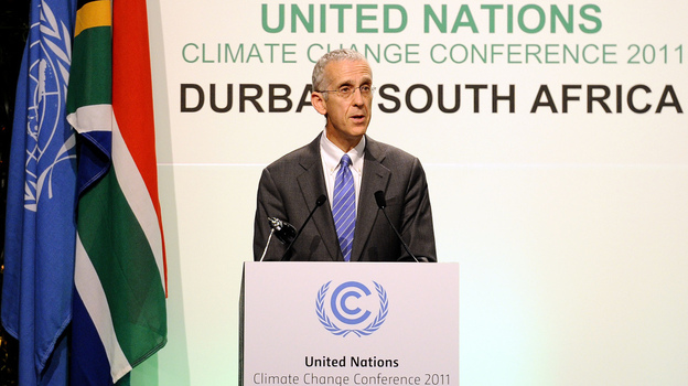
The day of the EarthView Team's return to North Reading Middle School happens to be on the last day of a United Nations meeting in eThikwene, South Africa, better known as Durban. Todd Stern was sent by President Obama to represent the United States at the meeting.


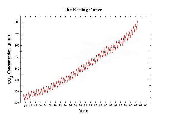
The last major agreement about climate change was made in Kyoto, Japan and is about to end. China and the United States are the two countries that contribute the most gases to climate change, but neither country agreed to the Kyoto Protocol. The meeting in Durban is ending without a new agreement.

The Global Climate Change web page includes links to more resources about the geography of this important problem.

Wednesday, December 7, 2011

Geographic Literacy by 2025

The March 30, 2009 blog post Geographic Literacy by 2025 links to an article about geographic literacy from ArcNews, a GIS magazine from ESRI.

Deepest Mines

A March 30, 2009 blog post entitled Deepest Mines explains the concept of scale and how heat and pressure affect mines.

Friday, December 2, 2011

Advocating for Geography

Since 2007, close to 30,000 Massachusetts students have participated in EarthView programs. The curiosity and enthusiasm of thousands of students and dozens of excellent geography teachers throughout the Commonwealth continue to energize the EarthView team.

Unfortunately, the experience of in-depth geography education is still the exception rather than the rule for Massachusetts students. The Massachusetts Geographic Alliance is a network of geography educators that partners with EarthView and is advocating at both the national and state level for more geographic education and more in-depth preparation of teachers in this crucial area.

Visit the MassGeo blog for the latest information about efforts at both levels, particularly for information about Senate Bill 182.

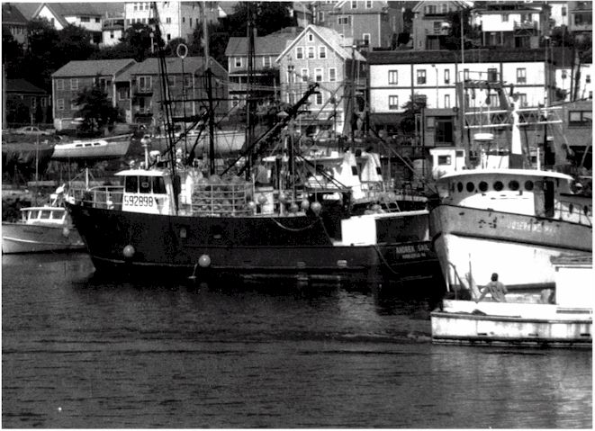
Andrea Gail

Andrea Gail before the shipwreck, Gloucester Times
The George Clooney film The Perfect Storm was, for many people, the introduction to the perils of commercial saltwater fishing. Coastal communities in Massachusetts are all too familiar with the risks. Even on ships with a multitude of modern technologies -- such as the Andrea Gail -- fishing remains one of the most dangerous professions in the United States.

The tale of how three North Atlantic storms converged was first told in a book of the same name by Sebastian Junger.

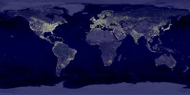
Earth at Night NASA


This is an image mosaic, meaning that many images were "stitched" together to make it. It shows what the earth would like like if we could see it all at once, without cloud cover. Because neither condition is possible, hundreds of images are combined in this single mosaic.

On this image, light is a proxy for population, meaning that it tends to be found in the same places as humans. For this reason, we can see the places where humans live in large numbers and the places that human settlement is more difficult. Generally, the places that do not support agriculture do not support large numbers of humans. Places that are too cold, high, wet, or dry may have human settlement, but at low density. 


Exceptions are often found where some natural resource attracts a population of workers.


Light is not a perfect proxy, though. Notice, for example, that South Korea appears almost as an island, because North Korea is barely visible. Some places with stronger economies look as though they have far more people than they actually do.


Some specific features show up very well on this mosaic. For example, the distribution of population in Egypt exhibits a form not found anywhere else on the planet. 


Visit the APOD page for technical information and a higher-resolution version of the image.