EarthView team bios, guidelines, and more.

Wednesday, February 29, 2012

Littleton Middle School, March 2

42° 32' 32" N
71° 29' 14" W 
Learn more about Lat/Long (including how to look them up by address)
Also, compare today's coordinates to those of other recent EarthView outings!


View Larger Map


The EarthView team is pleased to be making its first visit to Littleton Middle School. We have never had the privilege of visiting this school, but we have passed within a few hundred feet of the school many times, as it is located very close to Boston's outer ring road, I-495. We are very pleased to see that EarthView has been included on the school and district calendars.


We know it will be an enjoyable and learningful (we know that is not a real word) day!

We noticed from the schedule that sixth-graders will be coming to EarthView from several different classes, including math, science, foreign language, and social studies. We thank all of those teachers for their cooperation, and assure them that we can connect EarthView to all of these and more. Members of the EarthView team have visited well over 50 countries, and among us we speak about a half-dozen languages, for example, and with Pi Day coming up, a lot can be done with EarthView and math. And of course geography is both a natural and a social science, as well as an art.

The EarthView team is particularly energized this week, as we welcome the Globe Lady back from some tropical travels, Dr. Domingo and Dr. Hayes-Bohanan have recently attended the Association of American Geographers Annual Meeting in New York City, and several members of the team spent last Friday at the Map Center of Boston Public Library and the Mapparium in Boston's Back Bay.


Littleton is known as the earliest commercial producer of apple juice, which remains an important product today. This is appropriate, since Littleton is 15 miles east of Leominster, the birthplace of John Chapman, better known as Johnny Appleseed. Located at the edge of a major apple-producing area -- and between that area and thousands of potential customers in Boston -- Littleton was an ideal place for a vinegar factory. Eventually, juice became a preferred product from the same raw material.

In late 2011, Hurricane Irene was followed by an unusually heavy snow storm a couple months later. One results is that many trees have been damaged or lost, and the community understands the value of trees for their beauty, providing cleaner air, moderating winds and temperatures, and providing habitat for birds and other wildlife. For all these reasons, the town is replacing many trees free of charge through a special program this spring.


Our visit to Littleton takes place at the end of a week of tragic damage done by tornadoes in the United States. The majority occur in the United States. Tornadoes can only develop where cold fronts advance into warm, moist air. This is most likely in mid-latitude locations where cold, dry air from polar regions can meet warm, moist air from tropical regions.

The National Severe Storm Laboratory is part of the National Weather Service that studies tornadoes and other rare, extreme weather events. Geographers and other scientists there have created a Tornado Education page with more detailed information about what we know -- and are still learning -- about these powerful storms. Tornadoes can occur at any time of year, but those that occurred this week were considered unusually early. Tornadoes are most likely at whatever time of year cold and warm air are both available, so that they tend to shift toward the north over the course of a year.


Our visit is on March 2, which marks several interesting anniversaries.
(I usually list 3 or 4, but March 2 is an especially busy day, apparently!)


1904Theodor Geisel, (known as Dr. Seuss) was born in Springfield, Massachusetts
This birthday is marked by Read Across America Day, as described by librarian -- and honorary geographer -- Pamela Hayes-Bohanan.

1776Americans begin shelling British troops in Boston -- four months before Declaration of Independence
1799Congress standardizes U.S. weights and measures helping to unify the young country
1807Congress bans slave trade effective the following January. Slavery continued for almost 60 more years, based on existing slaves and their children and grandchildren.
1819U.S. passed its 1st immigration law
1819Territory of Arkansas organized
1853Territory of Washington organized after separating from Oregon Territory
1861U.S. creates Dakota and Nevada Territories out of the Nebraska and Utah territories
1867Congress passed the 1st Reconstruction Act
1867U.S. Congress creates the Department of Education
1896Battle of Aduwa, Abyssinia (Ethiopia) defeats invading Italians
1925Nationwide road numbering system and U.S. shield marker adopted
1933Most powerful earthquake in 180 years hit Japan
1937Mexico nationalizes oil
1939Massachusetts Legislature vote to ratify the Bill of Rights - 147 years late
1946Ho Chi Minh elected president of North Vietnam
1956Morocco tears up the Treaty of Fez, declares independence from France
1962Wilt Chamberlain became the only NBA player to score 100 points in a single game. Some credit this as beginning of the rise of African Americans star athletes in the United States.   
1970American Airlines' 1st flight of a Boeing 747
1970Rhodesia becomes independent republic (now known as Zimbabwe)
1983Compact Disc recordings developed by Phillips and Sony introduced
1983Final episode of M*A*S*H; 125,000,000 viewers

Wednesday, February 22, 2012

Chocolate Family

With cacao in Nicaragua
At EarthView presentations, I sometimes mention that I spend a lot of my time teaching and learning about the geography of coffee. Everything that is produced in some places and consumed in others has a geography, and coffee is just my favorite example among many.

Because chocolate is much more popular than coffee among our elementary and middle-school audiences, I sometimes mention cacao, the fruit from which chocolate is made. Yes, chocolate and coffee are both made from fruits. They share a lot of other geographic characteristics, often growing on the same mountains in the Tropics.

I always mention that although they are similar, cacao and coffee are not from the same family. During our most recent visit to the Richardson School in Easton, a very sharp fourth grader asked a good question: "If coffee is not in the chocolate family, what is?" This blog post is to fulfill my promise to find out, for I had never before thought to check!

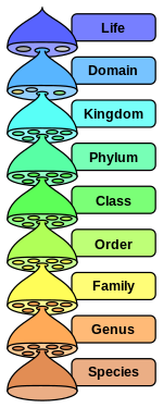
To begin the answer, we should identify each plant. Cacao is a single species from the genus Theobroma; its Latin name is therefore Theobroma cacao. (Wikipedia is not a source I usually recommend, but its coverage of Linnean taxonomy is informative and easy to navigate.) A close relative in the same species is cupuaçu, which is native to the Amazon rain forest. Many of my friends in the Amazon have cupuaçu trees in their yards -- I have enjoyed climbing the trees and eating the fruit, though its flavor is a little bit unusual.

Coffee is a bit more complicated, as two different species of the Coffea genus are produced commercially. About 70 percent of coffee is Coffea arabica, which was the first to be identified and which has the higher quality. About 30 percent is the robusta variety of the species Coffea canephora, which is almost always known simply as robusta. This is higher in caffeine and lower in quality, but easier to grow.

So what about the families? The Theobroma genus is part of the family Malvaceae, which includes some surprising cousins. One relative is the kola nut of tropical western Africa, which contains caffeine but is only sometimes used in cola soft drinks. Another is the extraordinary Baobab tree, which can live for up to 4,000 years! Most surprising to me, though, are that cotton and okra are also family members.
Baobab painting, Pew Gardens
Coffea is part of the Rubiaceae family, one of the largest families of flowering plants (any plant with a fruit has a flower). Its name derives from the word rubia for red, and the family includes chinchona, from which quinine is produced, and gardenia flowers.

The species of these two families are found throughout the world, mostly in tropical or other frost-free environments. Even those that are closely related may be native to different continents, evidence of the geologically recent emergence of the Atlantic Ocean between Africa and the Americas.

Friday, February 17, 2012

H.H. Richardson School, Easton -- Feb. 17

42° 03' 24" N
71° 06' 26" W
Learn more about Lat/Long (including how to look them up by address)


The EarthView Team is very pleased to be returning to H.H. Richardson in Easton, where we know students enjoy learning geography! The geography of Easton is interesting in a couple of ways. Like Bridgewater, Easton was once famous for making tools from local iron deposits. The same iron that give cranberries their red color was once considered a valuable resource for making tools in both towns, until bigger, purer deposits of iron made it more efficient to produce tools in other parts of the United States, and eventually in other countries.


Easton is also well known in this area for confusion about its name. Easton has only one town government and one official name. It is often thought of as two towns -- North Easton and South Easton -- though no map shows the line between the two.


Today's EarthView visit takes place on some interesting anniversaries.


It is the 49th birthday of geographer and basketball star Michael "Air" Jordan. He decided to major in geography after traveling to Venezuela for a basketball tournament in 1983. He went on to become one of the most famous geography students ever, along with Mother Theresa.

On this date in 1897, the National Congress of Mothers met for the first time. It later became the National Parent Teachers Association - PTA.
On this date in 1947, the Voice of America began radio broadcasts into the Soviet Union.
On this date in 1964, the U.S. Supreme Court ruled that all Congressional districts needed to contain approximately the same population. This affects how Congressional districts are chosen each ten years.
On this date in 1972, U.S. President Richard Nixon visited China, ending 25 years of isolation between the two countries.
On this date in 2002, the Transportation Security Administration was put in charge of airport security in the United States.

Monday, February 13, 2012

Straits of Hormuz

A lot of questions in history and politics are best understood through the lens of geography. Matt Rosenberg explains a geographic consideration that strongly influences how the United States and other industrial countries relate to Iran. The strait of Hormuz is a 21-mile wide passage shared by Iran and Oman, but a two-mile-wide channel within that strait has great importance for the entire world.

Nuna - Rodinia - Pangaea - Amasia

The interior view of the planet makes EarthView an excellent place to learn about plate tectonics. The plate boundaries shown inside highlight zones of convergence such as the Pacific Ring of Fire and zones of new creation, such as the Mid-Atlantic Ridge and the African Rift Valley. We can see that when two continental plates collide, as the Indian subcontinent continues to do with the rest of Asia, impressive orogeny (mountain-building) can result.

What we see now is a result of the greatest break-up since the Beatles (actually, it predates the Beatles by quite a bit) -- the transformation of the Pangaea into Laurasia and Gondwanaland, and eventually into the continents we know today.

This leads many EarthView visitors to ask, "What's next?" In other words, will the continents eventually drift into each other again, or will they all be subducted into the mantle? None of us will be around to see the answer, of course, but Ross Mitchell at Yale posits that 100,000,000 years from now, Amasia will coalesce around the present North Pole. If so, it would be the fourth supercontinent to form at roughly a 90 degree angle away from the most "recent" one, as Nuna, Rodinia, and Pangaea have in the distant past.

Saturday, February 11, 2012

Spellman Stamp Museum

See Gatehouse News story.
This pair of stamps is a wonderful example of the geography lessons that can be explored with stamps. Some places are made significant by the monuments that people erect, and the two shown in this image are among the best-known in the United States. They are framed in this view by cherry trees that were a gift to the United States from the country of Japan. The annual blossoming of the cherry trees draws visitors to Washington DC in the spring of each year, reminding us of the connections between the two countries, and of the similarity of climates between the Mid-Atlantic region of the U.S. and much of Japan.

The Spellman Museum of Stamps & Postal History is full of lessons of this kind. The museum opened on the campus of Regis College in Weston on May 4, 1963. It is one of only two dedicated stamp museums in the United States, the other being part of the Smithsonian Institution. Cardinal Spellman built an impressive  stamp collection through his own travels and gifts from church members and friends.

The museum built around that personal collection now serves thousands of visitors each year. The Spellman Museum's education programs provide insight into the history of stamps and postage systems, as well as general education on geography and many other subjects. With both permanent and changing exhibits, the Museum is an excellent destination for field trips and repeat visits, as the Gatehouse News recently reported.

Friday, February 10, 2012

St. Mary's School, Taunton -- Feb. 10

N 41°54'21"
W 71°05'39"
Learn more about Lat/Long (including how to look them up by address)


The EarthView Team is pleased to be visiting St. Mary's Primary School in Taunton, just a few miles southwest of our campus. We enjoy and appreciate this school, which enthusiastically includes geography at every grade level in its curriculum.

St. Mary's is in the heart of the City of Taunton, near the famous Taunton Green, a classic New England Town Common. Taunton is known as Silver City, for its historically important silversmith industry.

Friday, February 3, 2012

Stanley Elementary, Waltham -- February 3

N 42°22'04"
W 71°15'08"
Learn more about Lat/Long (including how to look them up by address)

The EarthView team is making its first visit to the Stanley School in Waltham, and we are pleased be arriving during a very exciting time for the school. Artist in residence Joshua Winer is working with the entire school on a mural, and we will be delighted to see this work in progress.