EarthView team bios, guidelines, and more.

Friday, October 26, 2012

Tracking Sandy


REVISED Monday, October 29, 9 a.m.

The National Hurricane Center is the best source of information for the expected paths of tropical storms, including hurricanes. The 5-day Forecast Cone for any active storm shows the most likely path, the expected intensity, and the spatial range of likely paths. It is called a  "cone forecast" because the predicted paths for the first day or two are narrow, widening further into the future.

MONDAY MORNING NOTE: We have updated this post about twice each day since last Thursday, in order to document the changing forecasts of Hurricane Sandy. As of Monday morning, the storm has not yet made landfall, and its exact path remains uncertain and very unusual as it interacts with other storms. The National Hurricane Center cautions that the exact location of the center is not very important as this is a very wide and slow storm, with the highest winds not necessarily near the center.

The cones are revised as geographers and meteorologists learn more about the behavior of each storm over time. Compare the forecast cone from Thursday afternoon ...


with the cone generated Friday morning ...


and with this cone Friday evening:

By Saturday morning, the cone had narrowed somewhat over water, as the range of estimates for the location of the storm's landfall also became narrower. Notice that landward side of the cone remains fairly wide, because it remains difficult to predict how the storm will interact with a northern, jet-stream storm that has forecasters quite concerned..


By Sunday morning, the possible ranges of Sandy's path had narrowed, and it had become apparent that it will turn northward after weakening near the center of Pennsylvania. It is also likely to maintain tropical-storm strength into Friday, a bit longer than had been expected.


As of Sunday evening, the storm had moved northward, and its path was expected to turn further toward the east, with the possibility of turning  directly into New England late in the week.


By Monday morning, the northern portion of the storm was affecting Massacusetts, though the center was still hundreds of miles to the south. The storm was expected to slow even further, tracking somewhere into northern New England or southeastern Canada in the early hours of Saturday.

These and other graphics generated by the National Hurricane Center are created with the use of very strong geographic and cartographic skills. For example, the following map indicates the expected probability of winds at tropical-storm strength being observed at some time during a 120-hour period. Similar maps can be viewed for expected precipitation.


In turn, information from the NHC is combined with other kinds of geographic information as people in many kinds of organizations make geographic decisions as they prepare for the storm. Retail companies such as grocery and hardware stores are making important decisions about the trucks that are moving from all over the United States toward the areas that are expected to be affected. How much material should they send? Where should they send it? When? Are there safe places near the storm where supplies should be sent temporarily? All of these are complex, geographic questions with very important consequences.

Thursday, October 25, 2012

Getting Around


More than 110,000 people have used EarthView since we began the project in 2007. Recently, we began working on EarthView Experience, a Google Map that provides two kinds of information. First, it shows where EarthView has been (purple pins) or is scheduled to go soon (yellow pins). Most but not all of  these locations are in Massachusetts.

The other purpose of this new map is to give some idea of where members of the EarthView team have lived or traveled, with just a few examples from each of the states or countries we have been to. Collectively, we have been to all 50 states and more than 50 other countries.


View EarthView Experience in a larger map

El Volcán Más Pequeño del Mundo

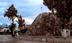
Popocatepetl as seen from Cholula. Clearly, this is
not the world's smalllest volcano!
Image from Nicho blog post about this amazing volcano.
A great part of Project EarthView is the questions students ask us about geography. At North Andover Middle School today, a student asked a question that took me (Dr. Hayes-Boh) back to one of the most enjoyable trips of my life (so far).

After learning about the recent eruption of San Cristobal in Nicaragua, a student asked, "What is the smallest volcano in the world?" It sounds like a difficult question to answer, because the "smallest" of anything tend to be much less known than the largest. In this case, though, I happened to know the answer right away -- though I confess I had forgotten the Nahuatl name for it.

As we prepared for our 1989 visit to central Mexico, my wife Pamela and I had read that Puebla -- the city where we would be spending the summer -- contains "El Volcán Más Pequeño del Mundo." As we entered the city we saw the enormous Popocatepetl and Itzatccihuatl, and thought the smallest volcano must be nearby.

Photo: Pam Hayes-Bohanan
A few days later, we were atop the pyramids in Cholula (shown above, it was the tallest structure in North America in 1491) when we asked a local friend -- who is still a friend -- where the world's smallest volcano was. "Oh," he laughed, "you can't see it from here. It is really small! But it is near my house, so you should come for dinner and I'll show you."

When we went to his house, I kept straining to see the volcano, and was wondering how people could be so sure they had found the smallest one. And then we stepped around a corner and there was Cuexcomate -- and its world-record status was obvious! Pam documented our Cuexcomate visit and other memorable parts of that summer, and Geo-Mexico provides a lot of details about this unique volcano.


View Larger Map

OTHER QUESTIONS: To other recent questions from students, we would like to offer some brief answers. The Seven Summits (or Seven Peaks) are the highest mountain summits on each of the seven continents (where all of Oceania is considered a continent, rather than Australia). As described on Geography at About.com, the term Seven Seas has at least three meanings. It can refer to a life spent on seas in general, to seven particular seas of particular importance in the early history of Europe and southwest Asia, or to today's seven major ocean basins.

Mystery Solved


Neckties are among the favorite props of the EarthView team. When the EarthView program began, Professors Domingo and Hayes-Bohanan each grabbed a favorite flag tie, and continued to wear them to most EarthView appearances.

Although we are geographers, our knowledge of vexillology is not complete (nor is our knowledge of geography, of course). So we were sometimes stumped when students asked us what countries are represented by particular flags on each tie. Recently, we created online quizzes for each tie (see Domingo tie and Hayes-Bohanan tie), both to help students and to make sure we would know all the flags. Most of the flags were easy to identify on lists of national flags, but the flag shown above did not appear on any such list.

It is difficult to search images without any descriptive words, so we put the question of this flag's identity to geographer Matt Rosenberg, who manages the popular Geography page on About.com. He in turn sent the question out through his social networks, and quickly learned that this is the flag of Sint Maarten.

Sint Maarten is a constituent country within the kingdom of the Netherlands. It shares the Lesser Antilles island of Saint Martin with the French overseas collectivity that is known at Saint-Martin.

During our recent visit to North Andover Middle School, some students asked where these ties could be purchased. Even though my tie (Dr. Hayes-Boh) was purchased long ago, it is still available at the Tie Store, as is another world flag tie in a different design  .


Saint Martin (the island shared by Saint-Martin and Sint Maarten) is among the northernmost of the Lesser Antilles, an arc of islands to the east of the Caribbean Sea. It is located just to the south of Anguilla. Because of the small size of the islands and the relatively great distance among them, panning and zooming in the map below is a good way to learn the spatial relationships in the Lesser Antilles.


View Larger Map

Wednesday, October 24, 2012

North Andover Middle School -- October 25-26

42° 41' 36" N
71° 07' 15" W
Learn more about Lat/Long (including how to look them up by address)

North Andover Middle School has become EarthView's second home, hosting EarthView more than any other school and really helping to boost geography awareness throughout the North Shore. Excellent preparation of NAMS students throughout the year combines with the wildly successful Geography Family Night to make this school both special and especially spatial!

Not only has NAMS Family Geography Night earned special recognition from the Massachusetts Senate, but a five-minute video produced at NAMS last year is also used as part of EarthView's advocacy and outreach statewide.
During our visit, we look forward to meeting many family members and to taking the time to explore the world NAMD students. We will also be encouraging students to think about other ways to explore geography, such as the Mapparium in Boston's Back Bay and the Spellman Museum of Stamps and Postal History in Weston.

We will also suggest online games (see the permanent link on this blog), especially the game about Dr. Hayes-Bohanan's tie and the Nicaragua volcano game. (BSU geography students visit two of Nicaragua's fourteen active volcanoes every winter.) New: We have a game for Dr. Domingo's tie as well. See the "mystery solved" for follow-up information about these ties.


A student wearing a t-shirt from "I'm Just A Bill" reminds us of all the time EarthView and its team members have spent in the Massachusetts Legislature in recent years, introducing and promoting a bill to further geography education in the Commonwealth.

Monday, October 22, 2012

Port Cities


Photo by Amanda Valente, BSU

During our visits to the Burkland and Goode schools in Middleborough, we have been very impressed with the murals, including one depicting the importance of maritime connections in our region. This kind of public art is common in communities directly adjacent to the sea, but all the more important in places like Middleborough and Bridgewater, which are just far enough away that the connections might be forgotten.

For example, where the Taunton River divides the two towns, the Titticut area still bears the marks of an old shipyard, where tall ships were launched for use crossing the Atlantic Ocean. It has been many years since such a thing could be done so far upstream for three reasons. First, many bridges would block the progress of the ships. Second, the dam in Dighton would also be in the way. Third, and perhaps most important, Bridgewater and Middleborough no longer have white pines of sufficient size to make the masts of ships.

Nonetheless, both Middleborough and Bridgewater remain connected to the sea, through the connections of both towns to active seaports to the north and south -- Boston and New Bedford. Just after we noticed mural depicting earlier maritime activity in Plymouth -- whose historic port remains a great area to visit and learn -- we noticed a special article on port cities by our friends at Geography@about.com.

Sunday, October 21, 2012

Farmington, Maine -- October 19


N 44° 40' 08"  W 70° 08' 53"
Learn more about Lat/Long (including how to look them up by address)

EarthView has never been closer to the North Pole than it was for our visit to the University of Maine-Farmington on October 19, but it has still not reached the half-way point. (Classroom exercise: How much farther north would EarthView need to go, to be halfway between the equator and the north pole?)

As the EarthView Experience map shows, our primary mission is to serve students in Massachusetts, but EarthView is also dedicated to promoting geography wherever the opportunity presents itself, and the annual meeting of NESTVAL was indeed a special opportunity. The meeting is hosted each autumn by a college or university geography department in New England or the St. Lawrence Valley of Canada.


For this visit, the EarthView team included Drs. Domingo and Hayes-Bohanan and seven geography majors from Bridgewater State University who were at the meeting to learn more about geography and to compete in a region-wide World Geography Bowl. Some members of the BSU team may be going on to national competition next April.

The athletic department at UMF graciously allowed for our use of the gym all day, and the UMF geography faculty and students worked with the Maine Geographic Alliance to organize visitors and provide lunch for our crew. Visitors included UMF undergraduate education majors, local students from preschool through elementary school, and participants in a diversity conference that was taking place at UMF the same day.

See more photos from EarthView at Farmington on Flickr.

Tuesday, October 9, 2012

My Tie Geography

Many of the students participating in EarthView enjoy the flag ties that Dr. Domingo and Dr. Hayes-Bohanan often wear to the programs. Each contains a different, random assortment of national flags.

Those who are curious about the flags can now examine this segment from Dr. Hayes-Bohanan's tie, and compare it to a list of all the world's national flags for a quick lesson in vexillology.

(UPDATE: We had not been able to identify the flag in the bottom row, next to the Brazilian flag. It is somewhat similar to the flag of the Philippines, but not exactly. We eventually learned that it is the flag of Sint Maarten, which is a territory, rather than a country.)

To assist in learning these flags, see the "Dr. Hayes-Boh's Tie" quiz, the newest of several specialized geography quizzes he has created on the site.

To learn more national ties, see the flag quizzes on JetPunk. Notice the link near the top of the page, to quizzes at three levels of difficulty.

The GeoGames page has links to many more fun ways to learn geography, for many levels of difficulty and different learning styles.

Many EarthView participants express interest in purchasing our ties. We are not in the tie-selling business, of course, but we have found a source for Dr. Hayes-Boh's tie (which he purchased long ago at the Miami International Airport). It is available at The Tie Store, as is another world flag tie in a different design.

Thursday, October 4, 2012

Burkland and Goode Schools, Middleboro -- October 5


Henry B. Burkland: N 41° 53' 12"  W 70° 54' 37"
Mary K. Goode:      N 41° 53' 14"  W 70° 54' 42"
Learn more about Lat/Long (including how to look them up by address)

This is our second visit to the Burkland and Goode Schools. Please see the blog post from our January 2012 visit for some fun questions about the coordinates of these schools compared to each other and compared to EarthView's home base in Bridgewater.


View EarthView Experience in a larger map

Satellite images and online maps are a big part of modern geography science, and we are using them to keep track of where we have taken EarthView. The Middleboro section of our new EarthView Experience map shows three schools we have visited in the town. Without zooming in, can you tell which one is Burkland and which is Goode? What is the third marker a bit to the southeast?

We are very fortunate to have a geographer from Middleboro as one of our new EarthView Wranglers (the BSU students who help us with the EarthView program). Macee had a few interesting things to share with us about Middleboro (or Middleborough -- that's another story). She reminds us that this is the second largest town in Massachusetts (by area). What nearby town is even larger?

Macee provided this map, which includes a clue. Middleboro is highlighted, as is all of Plymouth County.


Macee also told us about the geography of the Burkland and Goode Schools themselves. Students used to progress from Goode (Grades 1 and 2) to Burkland (grades 3, 4, and 5), but now students are assigned according to the town geography, with every street assigned to one of the schools. Without a map it is not easy to see, but the Burkland streets and the Goode streets seem to be in the north and south parts of the town. We hope that some Burkland and Goode students can figure this out and use the "comments" button below to let us know for certain!

Buildings are an important part of the human geography of any town, and they change over time. Macee provided this photo of Main Street -- you can click to enlarge it. Notice that it has trolley tracks in the middle of the street. What other clues can you find to the age of the photograph. Can you find this location today? (Please don't stand in the middle of the street to find it, but perhaps you can come close to it.) Can you or your parents figure out which buildings are still in place and which have changed? What kinds of businesses might no longer be as important? What kinds of businesses would you find on Main Street today that  would not be found when this picture was made?

Did you know that Middleboro was once covered with ice, perhaps a mile thick? And as most of the ice melted, some huge chunks remained, and flowing water deposited a lot of sand, gravel, silt, and clay around them. These deposits became much of the land of Middleboro and the giant ice cubes eventually melted away, leaving holes for ponds. Some of those kettle ponds remain; others filled in with organic matter and became the perfect places to grow cranberries. This is one reason that Middleboro and neighboring towns became the world's most important cranberry producers.

The headquarters of Ocean Spray is located in Middleboro, at a site that was chosen with the help of a geography professor from Bridgewater State who passed away about ten years ago. Look at the map that shows the headquarters, and see if you can figure out why the site was chosen.


View Larger Map

One final piece of Middleboro geography is the Oliver Mill Herring Run, which was part of a field trip for university geography students this summer. Herring are anadromous fish that migrate from the ocean to their birthplaces in small streams. They are historically very important to the New England diet, but when industry grew in this area, the factories (mills) often interfered with the fish. More conscientious builders created fish ladders, which remain in use today, even after the factories are gone.
Photo by BSU Geography student
Ashley Costa (c) 2012.

Monday, October 1, 2012

Moving Plates

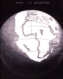
Last week's post for Collin's Elementary mentions some news about plate tectonics, and the possible breakup of the Indo-Australian plate. Just today, our friends at Geography.About.com have shared several new articles on the subject, including how Alfred Wegener developed the theory and how it relates to the Ring of Fire.

1858 map by geographer
Antonio Snyder-Pelligrini

For those who wish to know more, the USGS This Dynamic Earth includes more details, such as the earlier work of geographers and cartographers that helped to make Wegener's work possible.