EarthView team bios, guidelines, and more.

Friday, December 21, 2012

Apocalypse Not

"Tonight I'm gonna party like it's 

baktun 12 katun 19 tun 19 uinal 17 kin 19 Haab: 2 Kankin Tzolkin: 3 Cauac"

This winter's solstice coincides with the beginning of 2 baktun


I remember once pulling into a friend's driveway to take a photo when the odometer had turned over on our car. The car was no different on the way home than it had been earlier in the drive, but we stopped to mark the occasion. Similarly, we tend to celebrate our birthdays and anniversaries more if they are "major" -- 10 is a bigger deal than 9 or 12, and 100 is a really big deal. 

The mislabeled "Mayan Apocalypse" was simply a notable turnover of the "odometer" in an unfamiliar calendar system. It is a coincidence that the digits of today's date form an interesting pattern using a Gregorian calendar (what we use in the United States), just as they require an extra digit in the Mayan calendar. 

The opening line above is an allusion to the song "Party Like It's 1999," which the musician Prince released in 1982. At that time, New Year's Eve of 1999 seemed like a significant "odometer moment," and also seemed to be very far in the future!


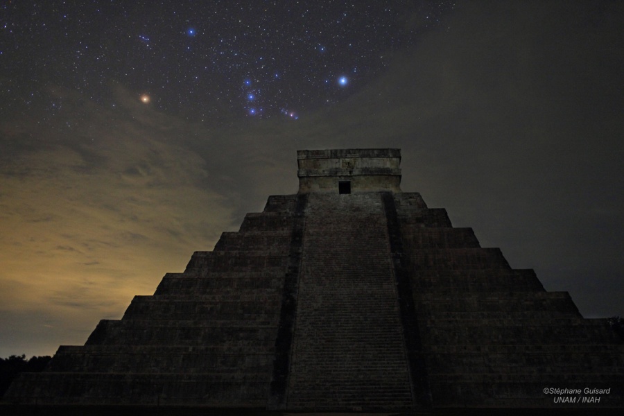
The NASA Astronomy Picture of the Day celebrates today's solstice and the flurry of attention to Mayan math and astronomy. Thanks to EarthView's administrative team member and former NASA scientist Dr. Diana Jennings for sharing this image. 

Astronomy, by the way, is related in many ways to physical geography. People of all ages are welcome to learn about astronomy at the new Bridgewater State University Observatory, which offers many public viewing nights and other programs. Both the Observatory and EarthView will soon be part of the university's Center for the Advancement of Science Education, which brings together all of the university's exciting outreach programs in science.


The Doonesbury comic for December 21 is timely and a bit cute. It gives the mistaken impression that Mayans are no longer present. Although not organized into a hierarchical society as they were when the Spanish arrived, Mayans are still found throughout the Yucatan and neighboring areas of Mexico and Central America.

In fact, Pam and James Hayes-Bohanan will be teaching about historic Mayans while working with contemporary Mayans in a college-level course next year, to be taught in Belize. It is called Maya Gold: The Geography and History of Chocolate in Belize!

Monday, December 10, 2012

Population Primer

Our friends at geography.about.com recently posted reposted an article about the growth of the world's population over the past twenty centuries and to the end of the current one. (The article also has a lot of links to other useful articles about population.) I quickly copied the numbers into Excel to make the following simple graph.
Viewed from Year 1 (A.D. or C.E. -- Current Era) until 2083, population takes the form of the letter J, or perhaps a hockey stick. That is, it grew very gradually for 1800 years (and for about 8,000 years before that), and really grew significantly only in the past century or two. The population has more than doubled, in fact, since the members of the EarthView team were born. This is not true of the Wranglers who are still in college, though the planet now has almost 2 billion people on it than when they were born!

A J-curve represents exponential growth, which shows no sign of stopping. A more careful look at these numbers, however, reveals that the growth is actually not shaped like a J. By graphing the data only since 1804, a subtle but important shift in the pattern can be more easily seen.
These are the same numbers, except that the earlier, long period of very slow growth has been removed. Rather than a J, the growth resembles an S, which is why this pattern is called sigmoidal, after sigma, which is the Greek letter equivalent of S.

This kind of growth occurs with many living things, including humans. Rapid growth often occurs when resources are abundant, and then slows as resources become scarcer. What looks like unstoppable growth slows down when limitations are reached.

In the case of humans, agriculture allows for significant growth, but industrialization allows for growth that is much more rapid, at least initially. Many regions have experienced what geographers call a demographic transition, as the rapid growth eventually slows. As explained on the BBC "Bitesize" article on population change and structure, these changes do not result from rising birth rates, but rather from falling death rates.

Most of the world's industrial countries -- such as the United Kingdom, the United States, Italy, and Japan --
have been through some version of the demographic transition and now have relatively slow growth, or even negative growth. Many developing countries -- such as Mexico and Brazil -- are near the end of such a transition. Most importantly, even in countries where population growth rates remain high -- such as Kenya and Jordan -- the transition is beginning, and growth is beginning to slow. (See the Census Bureau International Database detailed estimates of population change in these and all other countries.)

CLICK to ENLARGE
Mexico's current population pyramid shows that the country's population has
 been growing in recent generations, but that growth in the future
will be slower. This kind of graph is more properly called an
age-structure diagram because not all countries resemble pyramids.
The Census IDB generates diagrams for individual countries by year.
National Geographic provides a
 lesson on making andinterpreting the diagrams.
The result is that although human population is expected to grow by an additional 3 billion people before this century is ended, it is not expected to grow much beyond that.

For geographers and other scientists who are concerned about the demands a growing population places on natural resources, it is encouraging to see that the growth of population is slowing down. Biologist E.O. Wilson has described this curve as a "bottleneck" because it shows a period of rapid growth that is lasting for only a couple of centuries. For a long time before and after this period, human population growth was and will be very slow. Most of the plants, animals, and resources that survive this rapid change are likely to survive long-term, but survival during this period requires a lot of care and protection.


Saturday, December 8, 2012

Volcano Roundup

When speaking yesterday with North Reading students about my 1989 visit to the world's smallest volcano, one student asked about the world's largest volcano. By a variety of measures, Mauna Loa holds this distinction. It rises 13,677 feet above sea level, which is surpassed by many volcanoes, but nearly 30,000 feet from the sea floor, and 56,000 feet (eleven miles!) from its base within the ocean crust. It is so massive that the crust dips more deeply into the mantle below it. Mauna Loa is also a fairly active volcano, with 33 documented eruptions since 1843.


View Larger Map

Although located in the middle of the Pacific Ring of Fire, Mauna Loa is not part of the Ring of Fire. Rather, it is a hot spot volcano, similar to those that have formed Iceland and Cape Verde. Such volcanoes form in the middle of ocean plates, as they pass over hot spots deep in the earth. If the spot alternately hot and cool, the result can be a line or arc of separate volcanoes, with the most recent activity at one end of a long line of older volcanoes.


View Larger Map

More than three quarters of the world's 15,000 active volcanoes are found along the edges of the Pacific Ocean, where convergence between oceanic and continental plates results in both earthquakes and volcanic eruptions. (Fourteen of these are in Nicaragua, including the recently -- and beautifully -- erupting San Cristóbal.)

By some measures, the Yellowstone volcano is much larger, and is also considered active. A catastrophic eruption is theoretically possible, but the risks are considered remote by park officials.

When measured in terms of elevation above sea level, Mauna Loa is not even close to the top-ten list, all of which are Pacific-Rim volcanoes in the Andes of South America. The tallest volcano in the solar system, by the way, is a basaltic shield volcano on Mars. Olympus Mons towers more than 85,000 feet above the surface, with a base about the size of New York -- the state, not the city!

During our visit to North Reading, we also discussed some of the beautiful volcanic craters that had just been listed on the web site World Geography the day before. The first of these is Diamond Head, which is on the Hawaiian island of Oahu. The page lists a total of ten craters, each of which has a unique form that results from the volcanic events that created it, erosion and human activity since its creation, and climatic factors. The story of each is included, with a link to further information and an interactive map.
 Top-Ten List of Craters from World Geography
Seeing such fantastic images reminds us of other volcanic craters and calderas we have visited or hoped to visit. One of my favorites is Lake Atitlan in Guatemala, where I visited coffee farmers in 2008. A friend with whom I shared the Diamond Head photo told me that he had climbed the outer edge (it is very steep!) and had also visited the nearby Punchbowl/Puowaina crater, which has been both an ancient and a modern burial ground.

The United States Geological Survey is a good source of detailed  information about volcanoes in the United States and earthquakes worldwide. Its web site includes nearly instantaneous mapping of earthquakes, wherever in the world they may occur. The main USGS employs many geographers -- along with other scientists -- engaged in mapping and studying biological, water, mineral, and other natural resources.

Monday, December 3, 2012

North Reading Middle School - December 7

42° 34' 36" N
71° 05' 17" W

Learn more about Lat/Long

The EarthView team has visited North Reading several times. The most recent visit was almost exactly a year ago, on the last day of important climate-change meetings in South Africa. Similarly, this year's major climate-change meeting is ending on the day of our visit. It is being held in Doha, Qatar.

Qatar is a small country that emits three times as much carbon per person as the United States; in fact, it has the highest carbon emissions rate in the world. Qatar allowed its first-ever legal protests by visitors who objected to the contrast.

Protesters in Doha; image from Gulf Business
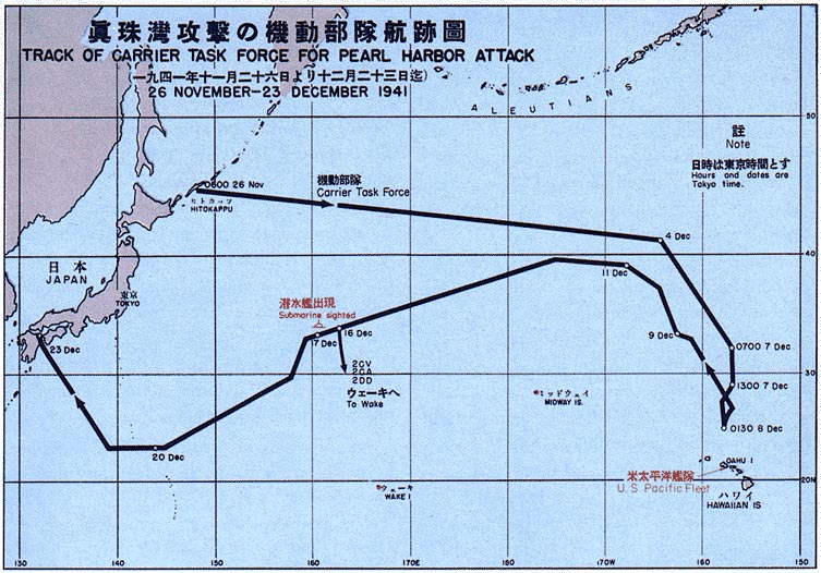
December 7 is also, of course, the "day that will live in infamy," according to President Franklin Roosevelt, as it was the 1941 date of the attack on Pearl Harbor that drew the United States into World War II. That single event was the beginning of many profound changes in the political and economic geography of the entire world.

Pearl Harbor was struck by planes flying from a nearby aircraft carrier. In 1966, the U.S. Government Printing Office produced maps that showed the path that had brought the carrier close to the island, and its route back to Japan.

Image: WikiMedia