
The coordinates of East Middle are at the end of this article. Usually, they are at the beginning of the post for each school visit, but because we are visiting two schools in the same town a week apart, we are making a small game of their coordinates.
(Learn about Lat/Long, including how to look up by address) See the end of this post for a Braintree-Bridgewater-Boston lat/long challenge.
What better place for EarthView to celebrate Halloween than one of our favorite schools -- East Middle in Braintree. Our first November program will be at another favorite -- South Middle. We have enjoyed both daytime programs and Family Geography Nights at both schools, because of the commitment of teachers and the entire district to global and environmental education through strong geography programs.
During our visit, we spoke about a lot of topics that can be explored in more detail through this blog, which includes an article about each school visit we make, and about many of the geography stories we tell using EarthView. This week these included the Wedding of the Waters in the Amazon, the relationship between Six Flags and Latin America. The right-hand side of this blog includes some permanent links to information we discuss during our presentations, such as the Geography of Coffee. We mentioned to several groups that BSU honors students had helped to create a map depicting the life (so far) of Malala Yousafzai. The map is included in Riveting Malala, one of over 700 posts on Dr. Hayes-Boh's college-level blog, Environmental Geography
During our visit, we spoke about a lot of topics that can be explored in more detail through this blog, which includes an article about each school visit we make, and about many of the geography stories we tell using EarthView. This week these included the Wedding of the Waters in the Amazon, the relationship between Six Flags and Latin America. The right-hand side of this blog includes some permanent links to information we discuss during our presentations, such as the Geography of Coffee. We mentioned to several groups that BSU honors students had helped to create a map depicting the life (so far) of Malala Yousafzai. The map is included in Riveting Malala, one of over 700 posts on Dr. Hayes-Boh's college-level blog, Environmental Geography
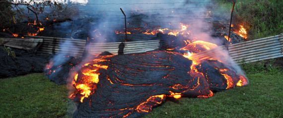 |
| Image: Huffington Post |
One of the many interesting geographic stories that is taking place during our visit actually began in June, when a vent on the Kilauea volcano began making its way toward the town of Pahoa, Hawaii. The movement has been very slow, but equally unstoppable, and residents are now preparing for the inevitable reshaping of their town.
We speak a lot about the Pacific Ring of Fire in our EarthView programs, but Hawaii is not part of it, even though it is in the center of the Pacific. Rather, the shield volcanoes of Hawaii are the result of an intermittently active hot spot beneath the Pacific Plate.
 |
| Read more about subduction-zone volcanoes and earthquake activity in our 2011 article about tectonic activity and Japan. All of the volcanoes in Nicaragua, for example, are formed by the processes shown here. |
The volcanoes of Hawaii, by contrast, originate with heat sources far deeper in the earth, as shown in this general model of hotspot volcanism.
The Geological Society-UK provides more specific information about the mid-plate hotspot responsible for the island chain of Hawaii It includes a video that is mainly useful for showing the relative timing and position of the islands in the chain, including Lo'ihi, which is so new that it is not even an island yet!
Other resources
For two kinds of disasters, it is easy to find authoritative information from agencies of the United States that employ geographers and other scientists to monitor and analyze information from all over the world.
One is the National Hurricane Center, which is part of the National Oceanographic & Atmospheric Administration, of which the National Weather Service is also a part. These agencies are part of the Department of Commerce. What other agencies are part of this department?
One is the National Hurricane Center, which is part of the National Oceanographic & Atmospheric Administration, of which the National Weather Service is also a part. These agencies are part of the Department of Commerce. What other agencies are part of this department?
Information about earthquakes is available from the Earthquake Hazards Program at the United States Geological Survey (USGS). Within moments of an earthquake anywhere in the world, the USGS posts detailed information, using a global, automated seismic network. The USGS also has a Volcano Hazards Program, which operates strictly within the United States and its territories.
It is disappointing that the volcano data are limited in this way, but it is because a lot of the important data comes from data monitors adjacent to and even on top of volcanoes. These monitors are maintained by agencies throughout the world, and they are not under the control of the USGS. The Smithsonian Institution does provide access to much more of the international volcano data.through its Global Volcanism Program.
All of the federal-government science sites mentioned here include plenty of explanations and glossary items. The data they generate is available free of charge not only to individual users, but also to commercial forecasters who repackage the information for other web sites, television, or radio, perhaps adding their own interpretations.
COORDINATE GAME
Each pair of coordinates below provides the unique location of a specific building in eastern Massachusetts. In alphabetical order, they are the Conant Science & Math Building at Bridgewater State University; East Middle School in Braintree, South Middle School in Braintree, and the State House in Boston.
The challenge -- draw a very simple sketch map showing these four buildings. Their exact locations do not need to be shown -- a general map from memory might be sufficient. Then match the coordinates to the building -- either by writing them on the map, or by listing the buildings in the correct order below. (Writing them down randomly is not likely to work: even with just four choices, they can be written in 24 different orders.)
42°11'02"N; 70°59'53"W
41°59'17"N; 70° 58' 19"W
Each pair of coordinates below provides the unique location of a specific building in eastern Massachusetts. In alphabetical order, they are the Conant Science & Math Building at Bridgewater State University; East Middle School in Braintree, South Middle School in Braintree, and the State House in Boston.
The challenge -- draw a very simple sketch map showing these four buildings. Their exact locations do not need to be shown -- a general map from memory might be sufficient. Then match the coordinates to the building -- either by writing them on the map, or by listing the buildings in the correct order below. (Writing them down randomly is not likely to work: even with just four choices, they can be written in 24 different orders.)
42°11'02"N; 70°59'53"W
42°13'15"N; 70°59'23"W
42°21'29"N; 71°03'49"W41°59'17"N; 70° 58' 19"W
Then verify your answers by consulting Google Maps or another detailed mapping resource.


